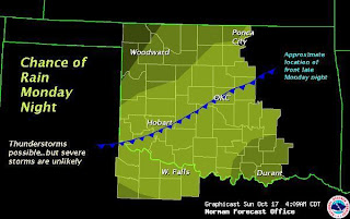
SPC Outlook for Monday. No severe thunderstorms are forecast.
So it looks like the forecast for Monday fell through. The NAM is showing the storm system hanging out farther west.
The lack of upper level winds will limit the severe potential for Monday. You can see the storm system out in the west coast of CA.
Another turn off is the general lack of instability and a stout cap.
Probably the only thing that will spawn off thunderstorms is the cold front that is forecast to move through the area. I am looking forward to the fall temperatures that it is supposed to bring, however.
There are some higher hopes for Friday, however. The GFS is showing a low pressure trough digging into the TX panhandle/western OK around 18z. Upper level support is better with this system and the combination of A sharpening dryline, moderate instability, and a mild cap are a good sign. It is still a little far off, but I have confidence in this system.
500mb chart for 18z Friday.
Surface temps and wind for 7p.m. Friday.
Nice dryline setting up right over the TX/OK border.
CAPE chart for Friday (18z). There is also a relatively weak cap in place over the area.
I hope these next few model runs will slow down the progress of this system. If it moves too far east, then we could see storms fire up east of I-35. I usually try to stay away from that area, the road networks aren't that great and there are more trees and hills there as well. The good news is that I have Friday off, but I was hoping for more of a "local" chase. Will keep y'all updated.
Thanks.
-Ben


Glad to see other minds thinking along the same lines ;)
ReplyDeleteRight now James and I are planning to chase Friday assuming we can get off in time.