I have lived in Texas all my life, and no other subject has filled me with both fear and awe at the same time like Texas storms do. This powerful weather phenomenon has always inspired me. The storms themselves are a work of art. Powerful winds aloft sculpt the towers into magnificent shapes and structures. Lightning lights up the night sky like an Independence Day celebration, and the booming thunder seems to echo forever. All of these factors are orchestrated like a symphony in the heavens. “Majestic Noise” is the name of this performance, and I am its audience. I love photographing and experiencing these storms. It is my passion, my calling, and my mission. When the severe weather rolls in, I go out to listen for that “Majestic Noise!”

Sunday, January 30, 2011

Winter Storm Possible Monday-Tuesday...

Water Vapor Imagery at 10:45 this morning. An approaching storm system could bring us a chance for winter weather early next week.

2011 winter season has left more to be desired. We've had our cold nights and patchy ice, but nothing as far as significant winter weather. I was just looking over the forecast for next week and it looks like the wait could be up. We're expecting more than just a few flurries for this one. Read on to learn more.

-Ben


A storm  system currently located in southern CA will make it's way through our forecast area by Mon/Tuesday. This storm system will bring along with it a very cold air mass which will likely result in winter weather.

NAM showing temperatures at 1:00pm. For our forecast area it is around 22 degrees Fahrenheit.

As this storm system moves through it will cause N/NW winds sustained at 25mph. This will result in very low wind chill temperatures and possibly blowing snow.

Projected sounding for Wichita Falls, TX. The close dew points and temperature lines below the freezing isotherm is a good indication for snow/sleet.


SREF models are showing accumulations around 1-2 inches for our area.


 Monday night 6pm: The freezing isotherm is expected to be right along and north of I-40 with chances of snow behind and along the front. The freezing line is forecast to reach our area by midnight Monday.

 Monday night midnight-6am: Snow/Sleet for our area.

 Tuesday looks like the big day for us. Snow and blowing snow.

It should be interesting to see what happens Monday night-Tuesday. If you are traveling please be careful and be sure to carry supplies (i.e. food, water, blankets) in your car. Nobody wants a repeat of 12/24/2010.

Wednesday, January 5, 2011

Cold Weather on the Way?...


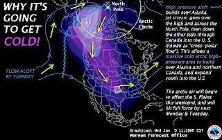
I was just looking over some of the forecast models and it looks like a very cold Arctic air mass will make its way down to us by Sunday evening. Low temperatures are expected to be in the lower 20's to teens through Wednesday! Here is a forecast synopsis from the NWS in Norman, OK.


Weather Synopsis...Temperatures will remain above average through Friday, before colder air filters into Oklahoma and western north Texas Saturday and Sunday. Much colder air will arrive next week as repeated surges of arctic air make their way into the Southern Plains. A prolonged period of subfreezing temperatures is likely next week. Although scattered light rain showers are expected across southern Oklahoma and northern Texas on Saturday, the greatest chance for widespread precipitation will hold off until Sunday and Monday, when a change to snow is expected. Although snow accumulations and reduced visibilities due to blowing snow appear possible late Sunday through Monday, significant accumulations are not expected. As it stands right now, the greatest impacts appear to be the cold temperatures and very low wind chill readings.

Should be interesting to see what comes of it currently the models are not showing much as far as snow in our forecast area.
132hr from the latest run of GFS under the "Snow Depth" model. Over the northern half of OK the models are placing 1-2" of snow. While our forecast area is expecting less than .25".

Well, better get out your heavy coats and gloves...

-Ben