I have lived in Texas all my life, and no other subject has filled me with both fear and awe at the same time like Texas storms do. This powerful weather phenomenon has always inspired me. The storms themselves are a work of art. Powerful winds aloft sculpt the towers into magnificent shapes and structures. Lightning lights up the night sky like an Independence Day celebration, and the booming thunder seems to echo forever. All of these factors are orchestrated like a symphony in the heavens. “Majestic Noise” is the name of this performance, and I am its audience. I love photographing and experiencing these storms. It is my passion, my calling, and my mission. When the severe weather rolls in, I go out to listen for that “Majestic Noise!”

Monday, June 17, 2013

05/17/2013: Elaisville, TX Chase


I have not been active in my blog in a very long time. But, I have been having an incredible chase season so far this year. May 17, 2013 will be one of my most memorable chases of my life. It was probably one of the most successful chases in my career and all around a fantastic storm chase. I experienced amazing supercell structure, large hail, high winds, and a beautiful close up of a photogenic tornado. Check out the chase log below and feel free to leave a comment. Thanks for all your support.

-Ben

Tornado hatch, notice that its only a 2% chance. Our lower level winds and dewpoints left more to be desired.
I was fortunate enough to leave early from work in pursuit of some developing thunderstorms just south of Archer City, TX
I left Wichita Falls a little after 5pm and drove south on US 281 to Windthorst, TX. Storms were moving  fairly slow and I felt I would be able to beat the storm.

One thing I noticed was the thunderstorms were trying to back build. In order to avoid (most) of the rain and hail I opted to head west and then hook around to get to the southeast side. 
While trying to get into position I was able to shoot a couple of photos of some of the storm structure. I would have loved to stay and shoot this, but I needed to keep moving in order to get ahead of the storm.


Heading south to Olney. At this point I'm wondering if I can make it ahead of the storm by "hook slicing"  may way through it. The meso hasn't wrapped up all the way yet.

The storm updraft starts to look a little more organized. While driving to the target I experienced some high winds and hail around golf ball size. 
This was the view to my south. Hail around the size of tennis balls is falling near Olney
I get a little ahead of the storm and pull over to shoot the updraft, but it still looks pretty elevated. I decided to head south on Hwy 79 to Newcastle.
Reports of 1.75" hail start to come in. At this time hail starts to fall in quarters and then increases to a couple of golf ball size.
1.5" hail stones in Olney.

Rain free base and developing wall cloud south of Olney.

New cell exploding just to my south. I wanted to get just to the southeast of it
so I punch through the core of the storm.


Double rainbow! I wish I could have stayed longer, but I needed to get south.


The storm is starting to organize and I stop in Graham for gas. The velocities on this storm were pretty impressive. Reports of 3" hail were coming in from Graham. 
Hook echo showing up on radar. Trying to beat the core and drive right under the meso. Heading west on FM 209 I get a great view of the storm's mesocyclone. 
Beautifully sculpted updraft and wall cloud. I pulled over for a few minutes to shoot this amazing updraft. The core was catching up so I had to head west.

I really REALLY wanted to photograph this updraft more, but I had to keep moving.

Under the wall cloud on FM 209 and FM 3109.

This storm was wrapping up quite nicely. An incredible RFD cut forms and carves a large funnel that (according to other storm chasers) reached the ground. I was up on a hill and couldn't see the ground.

Incredible tornado emerges from the rain/hail!

Large tornado not 500 yards from my location!!!
The tornado looks like it has just about finished, but I was in for a surprise. Since the trees and hills were blocking my  view I had no idea it was still on the ground.

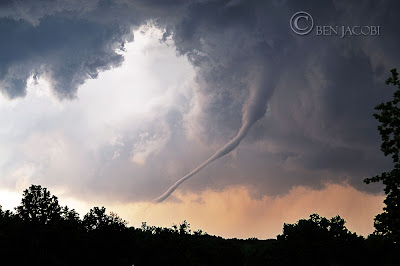
Without a doubt the best rope out formation I have seen. Although, I haven't seen many. 


Level II radar data of the storm. Classic hook echo and couplet on radar.

3D scan of the Elaisville tornado. I retrieved this image a couple of days after the chase from the radar archives. This volume data really helps with analysis of the tornado and mesocyclone.

Huge thanks to James Langford and Tim Jacobi for nowcasting for me!