
Thanks for the support!
-Ben
4/22 Chase Report:

SPC Day 1 outlook for April 22.

Tornado graphic. My target is Henrietta, TX. Just south of the 5% tornado hatch

Hail Graphic. Hail larger than 2" in diameter were expected.

Wind Graphic.
I haven't had a large amount of opportunity to storm chase lately, but there was no way I was gonna miss these storms that were expected to come through. A storm system was slowly making its way across the southern plains. A cold front was forecast to move through our area. Lift from the cold front/dryline would be enough to spawn off thunderstorms. Deep moisture return, strong surface heating were mixing to create a very unstable atmosphere and the upper level winds would support severe storms including supercells.

Around 2:00 the SPC issued a mesocscale discussion for the eastern half of OK and northern, TX. There was a growing concern for destructive supercells.

The discussion is eventually upgraded to a tornado watch for eastern half of Oklahoma.

Visible satellite image at the time the watch is issued. You can see a sharp dryline and an enhanced cu field over our target area.

NWS was monitoring the storms development and they were expecting initiation around 5pm.
I leave work early around 5pm. I get all my gear together, fill up the car with gas and get ready to go. The whole time I am standing under the cu field waiting for some towers to go up. I see a few towers that I think have the potential to bust through the cap just to my east.

The first storms start firing up! I am sitting in my target waiting for the dominant cell.

The cell just to the west of Wichita Falls explodes and starts to produce golf ball size hail. This is the storm I will go after. I stay in Henrietta and wait for the storm to cross my path.
This was the view of the storm from Henrietta just off of highway 148 N. This storm was rotating anticyclonic. A quick look of the radar revealed that the storm was beginning to split.

Another capture of the unique storm structure.

This is the radar image of the time of the split. You can see the main storm the southern portion of the northern split and another cell developing behind the main storm.

Outside of Henrietta on highway 148. You can see both downdrafts to the storms.

The storm takes more of a northeastern motion and I head back west to Jolly, TX. From there I turn north on FM 2393 and head right under the updraft of this storm.

This storm had a very nice meso structure on it.

And the sculpting of the updraft was insane!

I notice the development of a wall cloud with rapid rotation right over my head. Here is a base velocity scan with my GPS location. I am right in the middle of the storms rotation.

The wall cloud tightened up and produced this amazing white funnel! I was abut 100 yards from this funnel cloud. I kept checking the ground for visible rotation or a debris cloud.
The funnel thins out and shortly after I am blasted by the RFD. I estimated wind gusts around 65mph by noting large tree limbs were down and the fact that I almost got blown off the road. I head north to get back into position for another intercept. There is just one problem...

The storm is backbuilding and I quickly get engulfed by the core. Hail larger than 2" was beating down on my car. This was taken just before the core overtakes me.

Pretty decent size hail stones from this storm. I had a half dollar size stone hit me in the arm and leave a bruise. Also my car got some good dents and dings from hail close to baseball size!

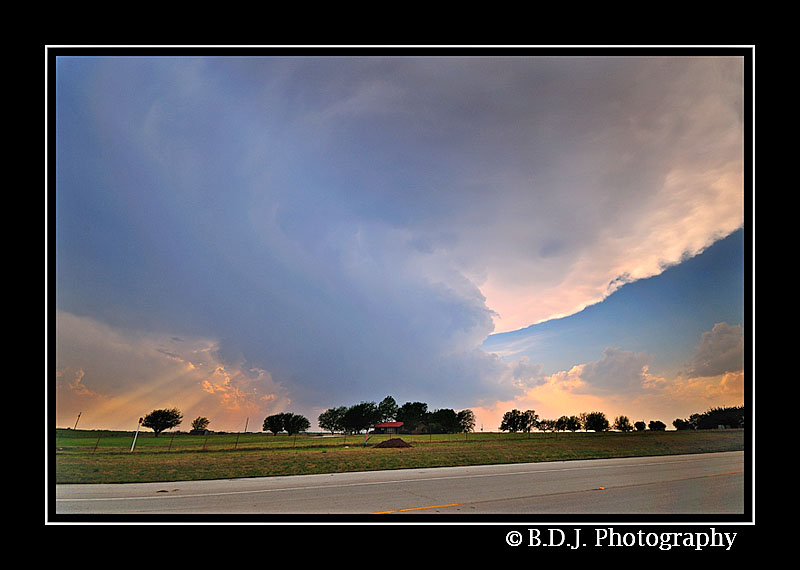
After getting swallowed by the core, I decided it was time to call it a day. The storms were starting to get more linear and take on a HP structure. I head home, but not before shooting this image.
My first really successful chase of 2011. All in all it was a great chase.
4/23:

Day 1 outlook for Saturday April 23.

Tornado graphic. Note the 5% area has drooped south into TX along the Red River.

Hail Graphic

Wind Graphic
Originally I had no intention of chasing Saturday. The day before the model runs were showing the cold front to be really far south along I-20. Abeline would've been my target. After I got done with Friday's chase I checked the weather models and an outflow boundary left over from yesterday's convection caused the cold front to retreat and stall along the Red River. Again, the upper level winds would support supercells, and plenty of instability to get the storms firing. My target would be Montague, TX and a secondary target for Decatur, TX. I was really trying to stay a little closer to home if I could. I head out around 2:00 for my primary target and I arrive there around 3:00.

By the time I reach my target area the SPC has issued a severe thunderstorm watch.

I sat just outside of Montague for about an hour watching towers go up and down, but nothing was really going.

This tower looked a little more robust and healthy. Maybe this was the one that would break out the cap.

The towers quickly explode and storm beginning to erupt in the cu field. This was taken from the "cockpit" of my car.

The cell just SW of Gainseville looks pretty good, but the problem is I don't have a definite route to Gainseville. I head down FM 455 to reach Forestburg (where the storm is currently located).

Because of my position relative to the storm I was able to get some different angles of the storm's updraft. This was really cool thing to watch bubble. If you watch the video below, there is a timelapse of this updraft.

Not long after the storm initiates it goes severe warned. I am currently in pursuit and I hope that I can make it to Forestburg in time.

I just miss the storm as it goes through Forestburg, but the storm kept seeding new cells downwind. I hoped that if I stayed along the southern flank I might see an isolated supercell. You can also see a cell to my SW this is the beginning of the Decatur supercell.

Captured in Foresetburg along FM 455. The storm had a nice structure to it with a nice lowering and even a possible funnel.

The cell goes tornado warned once it passes Forestburg and my location. It is heading right for Gainesville, TX now. I change my route to FM 922 and head NE to try to get in the inflow notch of the storm.

Just outside of Gainseville I pull over to shoot some structure. Listening in on the spotters and SKYWARN several reports of funnel clouds came in.

Close up of the storms wall cloud and another possible funnel.

This storm kept creating these little funnels, but never put anything down.

I am trying to get to I-35 so I can blast north into Gainseville and attempt another intercept.
I pull over in Gainseville and watch as the wall cloud gets completely wrapped up in rain. Just like the storm did earlier it forms another cell to the SW and I go after that. I have to drive through the core to get to the updraft area. Heading west on Highway 82 I have to pull over in Oak Ridge because of the hail. I saw about 2" hail pounding on my car hood and I wasn't planning to lose a windshield. Also the heavy rain curtains dropped the visibility to near zero.
Radar image of me in Oak Ridge. Shortly after the core passes. I head west again, but as I get closer to the updraft region a massive rotating wall cloud emerges from the rain curtains. I was in the direct path to the developing tornado with no data or cell phone signal. Not to mention the tornado sirens in Oak Ridge were going off.

I get out of that mess of a storm and head west on 82. Another isolated mini supercell formed and I spend the rest of the evening shooting its structure. It didn't really produce much as far as a wall cloud, but it did have a really interesting updraft/mesocyclone.

Mini supercell just outside of Muenster, TX off Highway 82. This storm was pretty photogenic.
So, another successful day of chasing. It was nice to chase back-to-back and so close to home as well. Below is a video composite of the two chases.


