
It
has been quite a while since I've last updated this blog, but now
with the season winding down I have the opportunity to finish up my
chase reports. I'll be the first to say that 2014 has not been that
great of a season for me. Responsibilities to work and other
commitments have conflicted with chase dates and I have missed a
couple of good chases, but here's the thing: There hasn't really been
any good chases in TX/OK all year! There has been chases, but in
Colorado and Nebraska but nothing much for the southern plains.
Usually this time of year we'll see some dryline magic, but our
dryline keeps mixing out and retreating west. Maybe we'll see
something these next few weeks. Regardless, I have still come out
with successful chases this year and April was a pretty good month. I
went on a total of four chases and busted twice, so not too bad. I
did miss a rope tornado that lasted for a few minutes due to re positioning on one of the chases, however. But check out the reports down below.
Thanks again.
-Ben
 |
The
lack of significant rainfall has led to extreme drought conditions
over almost all western north Texas, Texas panhandle, and southern
Oklahoma. Wichita Falls is entering in stage 5 drought conditions and
is 26.11” below its average rainfall. Lakes have been reduced to
puddles and lush green summer lawns have transformed into parched
brown wastelands that can only support weeds and grass burrs...
4/1:
April Fools Chase: BUST! Waurika, OK-Archer City, TX.
I
should have known from the beginning that this chase was not going to
be a success. I mean, April Fools? Who would chase on THAT day.
Evidently a lot of people. Leading up to the day of the chase I was
constantly battling between two target areas. Somewhere near
Throckmorton, TX and Lawton, OK. The HRRR was showing a nice isolated
supercell busting out around 6pm near Waurika, OK. Something in the
back of my mind was telling me to stick with my original target, but
as the saying goes “Think long, think wrong” I fell to the
trickery of the HRRR. We drove out to Waurika, OK and I had two of my
friends with me, one of which had never been storm chasing before.
|
 |
Visible
satellite at 5:30pm. There was a nice line of cumulus and convergence
right along the dryline and the mid level jet of 65kts over northern,
TX. Just underneath those elevated clouds there are cumulus towers
from Seymour to Davis, OK.
|
 |
Mixed
layer CAPE for 4pm shows little to no cap in place over Waurika, OK.
There is, however, an opening near Thrcokmorton the instability axis
is almost painting a bulls eye over our original target.

Watching
towers struggle to develop in the mildly capped environment.


Billy
and Tyler pointing out a developing tower to our west.


These
cows came up near the fence and when I went closer to get them in the
shot they all scattered away.

This
was the best looking updraft we had seen all day. If this one wasn't
going to go then nothing in this area would.


About
this time we decide to abandon this storm and head towards Archer
City, TX hoping to catch some lightning pics.
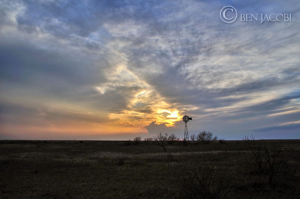
But
then I get distracted with some sunset rays and a windmill. It was a
nice distraction, though.


Beautiful
sunset and we are starting to see lightning from the storm to our
south.

Just
now reaching Archer City and the storm starts to collapse on itself
we pull over and witness the process. There was lightning flashing
constantly and we had a nice backlit view of the storm's updraft. It
was really interesting watching it shrivel up into almost nothing in
such a short time.


This was my personal favorite shot from this chase.
It was nice to end it on a good note.
4/2: BUST! Dundee, TX
Not much I wanna say about this one. I flat out missed
the forecast. We were hoping for storms to develop along the dryline
out to our west and I set a target for Seymour, TX and this time I
stuck with it! But storms didn't fire at all. So we ended up driving
around Dundee and somehow ended up on some oil roads outside of Lake
Diversion. It was an interesting place.

Tyler, Billy, and I hanging out on one of the lower
mesas in the area. We were kinda bummed we didn't see any storms.

This gives you an idea of some of the landscape that's
out there. I had the opportunity to go with a friend to the tallest
mesa out there it was pretty cool. I plan to go back out there again
sometime.

First Baptist Church of Dundee, TX
4/20: Childress, TX-Eldorado, OK
This was my first real successful chase for 2014. I
really didn't expect to chase this day. It was Sunday which is family
night at our house—also it was Easter Sunday, but my super awesome
family let me leave and chase storms. I ended up north of Childress,
TX and was greeted with a multicell storm with some potential after
chasing a couple of photogenic shelf clouds our first real storm
started going and ended up chasing two tornado warned supercells. One
of which produced a 3min rope tornado which I missed.

First
batch of convection forming in wake of a trough that was pushing
through the panhandle. After lunch I took a look at the radar and saw
this. Hmm...maybe I should head out that way there could be some nice
storms. I got approval from my family and loaded up my gear.

I
get in position around 4:00 and the storms didn't look all that
impressive on radar.

But
the storms are still photogenic. This was a quickly approaching shelf
cloud, not too long after this photo I had to leave to avoid getting
rained on.

Storms
start to increase in intensity and this one was starting to show
signs of rotation. I got a little too far ahead of it and missed a
rope tornado near Kirkland.

Updraft
of our storm as it edged through Goodlet, TX


Some
of the best contrast I've seen on a storm. Beautiful light...

Our
storm is moving more east than southeast and I decide to pull away
and find a route that would take me north and right under the storm.

About
12miles from the storm and I can see a great view of the updraft to
my east. I didn't realize how much this storm had started rotating
and I was able to capture a shot (while driving 75mph) of the
striated mesocyclone and beaver tail feeding into the updraft. I bet
it would look really good under the meso.

I
finally get to Quanah and take Highway 6 north

And
I stumble upon this beautiful pancake stack supercell!!!


A
new cell forms to the west of my current storm and I decide to
abandon the cell near El Dorado and head back towards Kirkland

Our
new supercell as seen through my car's windshield. I really wanted to
stop and take more shots of this storm, but I needed to be closer to
it first.

This
storm really started to get organized I found a great spot to pull
over without power lines and telephone poles. I watch this storm
cycle a couple of times and actually saw a possible funnel.

Small
needle funnel (center) that lasted for a couple of minutes, but died
out shortly after this image.

New
meso and wall cloud emerge from the rain just to my north east. About
this time I meet up with some local chasers from Altus, OK and we
watch the storm go crazy!

Closer shot of the low rotating wall cloud. We really
thought it might produce here.

But the RFD engulfs the base in hail and torrential rain.
There's no telling what's happening in there and the radar reveals
something intriguing

Tornado warning on our storm! The NWS issued the
warning for “a severe thunderstorm capable of producing a tornado”.
But with the rain blocking any view of the updraft base seeing a
tornado wasn't likely.

Panorama of the storm as the rain/hail core overtake
the updraft. This storm was becoming an HP beast.

The storm takes a quick direction change to the
southeast and starts to quickly move towards my direction. I drive
out east to stay ahead of it, but the light is fading fast. I find a
good place to pull over and shoot the outflow dominant storm until it
comes almost on top of me.


A great chase in a familiar area. Two tornado warned
supercells and some awesome structure. I was also able to drive home and arrive just at the end of dinner so it all worked out for a fantastic Easter
chase.
4/23: Thalia-Kadane Corner (Kamay), TX
Another great April storm chase in north western, TX.
Severe thunderstorms were once again expected to develop along a
dryline and impulse in the TX panhandle, favorable wind shear and a
decent amount of instability supercells were forecast to fire up and
move northeast into our area. Enhanced low level shear increased our risk
for tornadoes. Though we did not see any tornadoes we intercepted
three separate storms and caught some beautiful LP supercell
structure in dramatic sunset light.

Around
4pm the SPC issued a severe thunderstorm watch for our target area.
Some storms had begun to fire off the dryline in the TX panhandle.
Our target was Crowell, TX. I was able to leave work around 5pm and
we quickly headed west towards the dryline.

We
arrive near our target as two storms start to develop. I decided to
wait back in Thalia as the storms were going to be moving our
direction anyways and this way I could capture some wide angle
timelapse shots.

The
view of our storm as seen from west of Thalia, TX on Highway 70.
There is another storm to our south east and one to the south of our
current storm. You can see two sets of updrafts in this photo.

Our
first storm wasn't really that impressive. It was very elevated and
didn't show much sign of rotation.

The
cell to the south chokes off the inflow to our storm and are storm
withers away while the southern cell gains strength

But
it does put down some nice CG lightning. This strike in particular is
very close. I included a 100% crop so you can see where the bolt
strikes right in front of the power lines.


The storm to the south kills off our storm, but it is heading in the same
path so we don't need to re-position. We let the storm come to us.


 Tyler
mentioned something about a lowering in the clouds. I turned around
and could barely make out a nub shape. Its really hard to say its a
funnel. It did not look like it was rotating and nothing showed up on
radar.
Tyler
mentioned something about a lowering in the clouds. I turned around
and could barely make out a nub shape. Its really hard to say its a
funnel. It did not look like it was rotating and nothing showed up on
radar.


It
passes just to our north east. Reports of golf ball size hail started
coming in from Crowell. We even met a man who drove out from Crowell
just as the hail had hit. He didn't want to mess up his new Dodge Ram
2500 truck. The storm to our south east is really starting to build
up and is starting to show stronger signs of rotation. If we stayed
on the storm we were on we would be chasing between storms (which is
never fun).
Our
storm still looks elevated didn't really seem to root in the deep
moisture near the surface. We decide to head back to Vernon, TX and
try to beat the south east cell to highway 25.
Radar
and Velocity image of our new storm. This storm was starting to look
really good on radar with a nice couplet, a good hook echo and decent
hail core. The question was: are we gonna to beat the storm to
Highway 25? Well, we just barely make it as the edge of the storm
passes over 25. We did get into some heavy rain and some nickel size
hail. We end up in Kadane Corner (Kamay) and turn west on a farm
market road and meet up right under the storm meso.
Radar image as we barely beat the storm. It was around this time we saw heavy rain and a little bit of hail.
Now
that's an LP! A beautifully sculpted horseshoe RFD cut in setting
sunset light it really was a visual treat. We stay here and watch as
the updraft comes directly over us. This storm had the best rotation
of all that we saw the entire day.
Billy
and Tyler standing directly underneath the meso and looking up at the
elevated structure.
Soon
we we're hit with some rain and one little hail stone. I managed to
snap this pic before it melted in Billy's hand.
And
we end the chase with an astonishing rainbow and eddy spinning right
behind us.
April was a good month for storm chasing and it proved
to be a better one than last year. I made a couple of navigational
errors and forecasts, but it was overall very good. I managed to come
back with some beautiful image and share these memories with some of
my good friends.