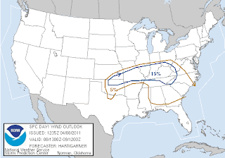
SPC Slight Risk Area for 4/8/11
My first chase of 2011. Was it a bust? Tornadoes wise, yes. We did see a little structure, but missed out on a storm that produced a nice tornado near Enid, OK. Was it a success? I'm not really sure. For a kinda big day, I was a little disappointed. Most of the storms didn't get really bad until after dark. All in all not a terrible way to start out the 2011 season. Read full report below.
Thanks.
-Ben
04/08/11 Chase:
SPC Tornado Graphic
SPC Hail Graphic
SPC Wind Graphic
We started out from my home in Wichita Falls, TX. A storm system off the coast of CA was throwing out impulses of energy as these impulses came through an unstable air mass severe weather was to be anticipated. Our original target was Kingfisher, OK. After looking at the high res weather models we decided to shift the target a little south. HRRR models were showing precip and an isolated supercell over Chickasha, OK. That would be our new target. The RUC was forecasting an incredible amount of CAPE almost 4000 J/kg!
SPC issues a mesoscale discussion for our target area: "Severe weather watch likely"
We leave Wichita Falls around 2:30 and shortly after a mesoscale discussion is issued for our target area. On our way to Chickasha we drive under an enhanced field of cumulus clouds. Several towers struggled to break the cap and yet despite CINH values at >-35 no storms fired. It wasn't until we got north of Chickasha that a cell finally broke the cap and began to erupt. The storm was just near Enid, OK and we were still over an hour away.
On our way to try to catch the Enid, OK storm. You can see the rock hard updraft and developing backsheared anvil
Tornado watch is issued for our target area.
We tried to catch up to the Enid storm, but we weren't going to get there fast enough. Sitting in Kingfisher we decide that its a lost cause and abandon the Enid storm. About the time we dismissed the storm more towers began to form along a subtle outflow boundary to our northwest and less than 30min away. We change our target to Fairview, OK and go after the storm.
Fairview, OK storm on radar
This storm had a height of around 54kft. Not bad...
Around Hennesy, OK we start to observe some structure, but the storm looks like it is trying to split. I decided for us to wait and chase the southern most cell.
It was a nice photogenic thunderstorm.
Reports of golf ball size hail were coming in now. You can see the sharp edges of the anvil.
This was Chad's first storm chase!
The storm begins to split, but our southern most cell doesn't look terribly impressive on radar.
This photograph was made while driving toward Fairview, OK. This storm had some bulgy mammatus clouds.
We were in position for an intercept when something catches my eye...
(Still from video) Is that a funnel? Scud?
We pull over to observe some more structure and watch for any more possible funnels.
It looks like our storm is trying to split again.
We run out of road options that will take us north, so we hang back and shoot these awesome sunset rays peeking through the flanking line of our storm.
As the sun sets and it starts to turn to night we turn around and head for home. Regardless of how the chase went we still managed to come back with some decent pictures.


That funnel sure looked convincing on the video. Nice catch any way, we totally missed it.
ReplyDeleteIt was amazing to see the change that came over those storms once the sun set and they approached the warm front.
Nicely done!
ReplyDeleteAwesome post. Thanks.
ReplyDelete