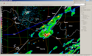
Happy Thanksgiving everyone! A potent Arctic cold front was moving through our area this morning. Around 4am isolated thunderstorms began to pop up on radar in Archer, Baylor, Clay, Jack, Montague, Throckmorton, and Wichita counties. These storms were forming just ahead of the cold front. One of these storms formed right over Wichita Falls and dropped pea-size hail, moderate rain, and frequent wind gusts around 40mph.
HRRR Surface temperature analysis. I overlayed the approximate location of the front. You can see temperatures south of the from are in the 70's north and along the front it drops significantly (upper 40's).
Base reflectivity from KFDR. This isolated storm formed right over us.
I was surprised to see hail with the storm. The VIL was only around 12 kg/m2.
Echo Tops
HRRR surface CAPE. There is very little instability over our area at this time, but the strong forcing from the front/trough was enough to generate lift and spawn off a few storms.


That is surprising... I would thank that that much hail would be accompanied by much more significant VIL values. I guess it must have really been cold upstairs for that storm to produce hail so easily. We didn't get anything like that down here. Not even much in the way of rain fall.
ReplyDeleteThat was a fun storm.
ReplyDelete