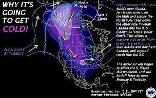
I was just looking over some of the forecast models and it looks like a very cold Arctic air mass will make its way down to us by Sunday evening. Low temperatures are expected to be in the lower 20's to teens through Wednesday! Here is a forecast synopsis from the NWS in Norman, OK.
 Weather Synopsis...Temperatures will remain above average through Friday, before colder air filters into Oklahoma and western north Texas Saturday and Sunday. Much colder air will arrive next week as repeated surges of arctic air make their way into the Southern Plains. A prolonged period of subfreezing temperatures is likely next week. Although scattered light rain showers are expected across southern Oklahoma and northern Texas on Saturday, the greatest chance for widespread precipitation will hold off until Sunday and Monday, when a change to snow is expected. Although snow accumulations and reduced visibilities due to blowing snow appear possible late Sunday through Monday, significant accumulations are not expected. As it stands right now, the greatest impacts appear to be the cold temperatures and very low wind chill readings.
 Should be interesting to see what comes of it currently the models are not showing much as far as snow in our forecast area.
132hr from the latest run of GFS under the "Snow Depth" model. Over the northern half of OK the models are placing 1-2" of snow. While our forecast area is expecting less than .25".
Well, better get out your heavy coats and gloves...
-Ben
-Ben


Super graphics and informative. Thanks, Ben. BRRRR!!!
ReplyDelete