
The 2015 storm
chase season has kicked off and with a bang! I have been on several
chases during the month of April and have had some success. April 8th
was the first chase of April and I had the opportunity to chase with
fellow storm chaser/photographer James Langford (check out Jame's
incredible work here http://www.langfordphotography.com)
and his friend Brad Neal. This was Brad's first storm chase so
expectations were high. The SPC was expecting storms to develop after
4pm along the triple point in south-central Kansas and the dryline in
western Oklahoma. We tend to chase more secondary targets than main
target areas due to chaser convergence. We had hopes of catching a
nice supercell and maybe even a tube all to ourselves. Read the
report below to see how the chase went. I am finally starting to get
some time to catch up on all these chase logs. Like I said—April
has been a very busy month.
-Ben
 |
SPC
outlook for 4/8/15. An enhanced risk was outlined around the two
target areas south-central Kansas and western Oklahoma.
|
April
8th
was shaping up to be the first big severe weather event of the
season. I was so confident in the chance for storms that I asked to
leave early so I could chase with James and Brad and get to the
target on time. Our initial target was Clinton, OK and areas west of
I-40. The HRRR was forecasting a nice looking supercell around that
area after 4pm. This storm had been on the previous night's 4km NAM
and WRF models. So confidence was high in our secondary target. I was
scheduled to leave around 1pm so we would have just enough time to
make it to our target just when storms start developing. At Wichita
Falls we were sitting at a mild 72 degrees and a dewpoint near 63
degrees. Thick clouds were hanging over our heads, but we could see
some a cu field far back in the west and the satellite was showing
erosion to the heavy cloud cover.
 |
Satellite
image at 1:15 just after we left. There is some nice clearing over
our target with some cumulus developing just off the dryline.
|
James
and Brad pulled up to the store and waited in the parking lot while I
finished waiting on customers and got my gear together. After a short
greeting and introduction to Brad we climbed in the Jeep and started
off to Clinton, OK. The farther north we drove the stronger the
surface winds got. Strong southeast winds of 15-20kts surged moisture
into our target area. By the time we get in range of our target we
can see towers going up on the dryline.
 |
The
SPC issued a mesoscale discussion for our target area around 2:30. Large hail/ some significant/ would be the primary initial hazard as the LLJ strengthens this evening...the risk for tornadoes / a few strong will increase as well...
|
We reached our target Clinton, OK and made a quick stop to fuel up the Jeep and check the latest data. We could now see an anvil off to our northwest. This storm was still on the dryline, but it was a promising sign. Storms had reached convective temperatures and once they got off the dryline the chase would soon begin.

Tornado watch issued for our target area as the dryline storms start to move into western OK.
 |
The chase is on! First cell fires up on the dryline and we head off west in pursuit of the storm.
|

On the road and heading west on S33 to get a better look at the storm. This updraft had an
incredible back shear anvil.
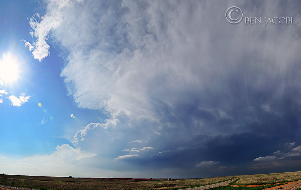
We find a spot to pull over and we have a nice view of our storm, but the anvil isn't looking
as sharp and defined. There was a new updraft developing on the southern part of the
storm, however. I shot a panorama to capture the dying anvil and new updraft tower
in the frame.
 |
This updraft was starting to get going. It was beginning to look like we had our storm!
|

20 minutes later we have explosive development and this bomb of an updraft climbs into the
atmosphere. This kind of stuff makes for an excellent timelapse video.

A new cell rapidly develops to the south of our storm. The anvil is much weaker and fuzzy
looking. It was going to be interesting to see what happens when the storms collide.

Very wide panorama to capture both storms. James and Brad are seen in the center of the
frame. James was shooting stills and timelapse of the storms colliding.
The storms never actually collided, but the northern cell did ingest the southern cell and it seemed to gain strength when it did. The storm moved off the dryline and starting to develop a mesocyclone and rotating wall cloud.

We found a picturesque scene to pull over to with our storm in background. You can see some
nice structure on the updraft and a lowering just left of the tree. We were south of Leedy, OK and
still several miles away from the storm, but we could see a rotating wall cloud
and maybe even a funnel.

Radar scan around 5:39pm the storm is starting to organize and there even seems to be
a hook forming.

A little more north now and we find a spot with minimal hills and trees, but unfortunately we
have to deal with some high voltage power lines cutting right across our scene.
But we still had a great view of the storm's updraft and mesocyclone.
Around this time the wall cloud tightened up and we saw a pretty convincing lowering
from the rotating wall cloud.

The storm had latched onto a boundary which we believed to be the sagging warm front.
The storm started to go crazy. We witnessed some strong rotation and some really
beautiful structure.


James
and Brad observing
the amazing structure. I had to shoot a very wide
panorama to get the
sun and the rainbow (far right) in the frame.

The
storm began to move off the boundary and seemed to weaken.
Nevertheless,
the light and movement of the clouds made for a
dramatic timelapse sequence.

Our
main concern today was the early morning precip and how it would
affect the environment of our storms. We were worried that the storms
would ingest colder air and kill off the updraft and the chance for
tornadoes. This storm looked like it was doing just that. It moved
off the boundary in the more stable air, we lost our wall cloud,
inflow bands, and our anvil weakened. It was still an awesome sight
to witness, however.
We kept pressing on thinking our storm might reorganize.
After the storm passed to our northeast we thought we could see what
looked like a new wall cloud forming. Was the storm getting into
better moisture? But while driving we did see the lowest wall cloud
we had seen all day. Maybe our storm wasn't done just yet. To get in
the right position for the storm we had to zigzag through some farm
roads in the western OK hills. It was some really nice scenery there
were several times I wanted to stop to shoot some landscape images,
but we were on a storm chase.

Just
south of Highway 60 we pull over on a hill and watch the storm's wall
cloud.
It didn't seem to be rotating as much and the whole thing had
a “cold” look to it.

Although
this wall cloud was low it didn't have that much rotation to it and
the NWS dropped the tornado warning. It was even starting to lose
reflectivity on radar.

We
are now west of a wind farm in Cestos, OK. Our storm has lost its
base and is collapsing in on itself. We stop here and decide to shoot
some timelaspe of the dying updraft.

Our last view of
our storm before we abandoned it. Not a bad place to set up with the
wind turbines in the foreground though.

One of my favorite
things about chasing is the opportunity to explore new places. This
wind farm was very new and had been up less than a year. The turbines
made for some great focal points in this composition. Meanwhile the
TX/OK border is lighting up and the anvil from a cluster of storms is
coming over our sky. This could be interesting for the sunset...
The storm to our
southwest is spreading its anvil over our heads and we can just start
to make out some mammatus structure. The storm tracks just to our
south and we are left with an amazing mammatus display in stunning
sunset light!


And a double
rainbow!

James new chase
vehicle did really well today and we were glad to have it.


Panorama of the
amazing mammatus clouds right above us.

The sun has set
below the horizon, but now a new show is starting we can start to see
some pretty nice cloud to cloud lightning on the storm to our south.
This was the last photo I took before we left to get out of the
falling rain.

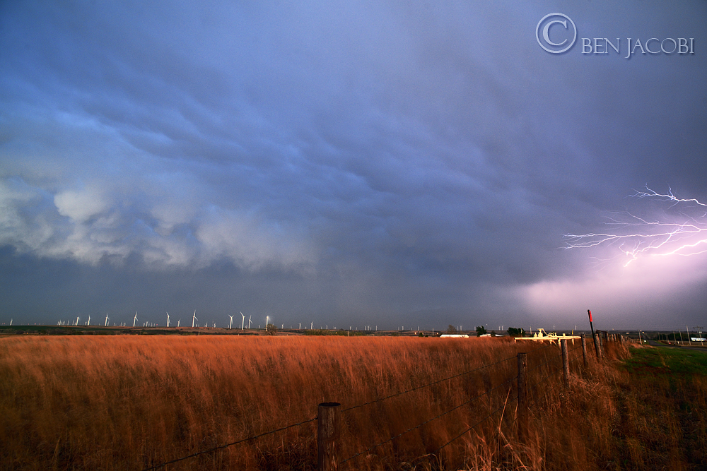
What's better than
some anvil crawler lightning? How about anvil crawler lightning over
a wind farm!
After we get our fill of lightning photos we punch south
towards Putnam, OK and start heading towards home. I should've been
paying more attention because we ended up driving right through the
core of a developing storm and got some gusty winds and hail that
ranged from pea to quarter size. Luckily, it was still very new so we
didn't get into anything too terribly bad. We noticed an increase in
the lightning off to our west and decided to head south and get far
enough ahead of the storm to get some lightning shots. I took a quick
look at the latest radar data and I was in for a surprise.

Whoa! The storm to
our west has a tornado warning on it and the radar shows a nice hook
and strong velocity couplet!!!

We pulled over off the highway and started scanning the
western horizon waiting for lightning to flash so we can catch a
brief glimpse of some storm structure. After not seeing anything we
move further south to be greeted to a convoy of storm chasers coming
off Highway 33 trying to get ahead of the storm. We had gone most of
the day without seeing any other chasers. It was actually quite nice.
Don't get me wrong I'm all for seeing other chasers, but when there
are over 100 vehicles scrambling to get to the same storm it becomes
more about navigating around chasers and not watching the storms.
That's why we picked the secondary target. I couldn't imagine what it
was like up in Kansas. Around 9:30 we call the chase done and head
back to Wichita Falls. We stop at Whataburger to discuss the chase,
check weather reports, and garb a quick dinner. It really was a
fantastic chase. I don't believe I've had a chase that good since
2013. We didn't see any tornadoes but it wasn't a bust. Saw some
amazing storms over some beautiful terrain and even met a new friend
so far 2015 was looking pretty good!
No comments:
Post a Comment