
Well, here we
are in the first week of April on the cusp of severe weather season
and so far we have had pretty decent chase opportunities in this
area. While I haven't had a lot of success, it felt good to be back
on the road chasing some storms. I actually chased three different
times in March and came back with some great photos. Hopefully, we'll
have even better chases in April! Check out the chase reports below.
March 19 :
Bust
March 19 was
the first chase of the season for me and sadly it was a bust. Not
because storms didn't fire, or I picked the wrong target. The main
problem was I was not able to leave work in time. I couldn't break
away from work and ended up behind the storm. When I did leave the
storm was already almost to Bowie (about 50 miles away) and some of
my chaser friends were right under it witnessing a developing wall
cloud. I spent most of the time in the anvil and FFD of the storm
trying to get around it. I made the decision to not core punch it
because the radar was indicating 2” hail and I really wasn't
planning on losing my windshield early in the season. After about an
hour of getting nowhere and losing light I finally opted out of the
chase and started back home to Wichita Falls. I did manage to get
just a few photographs. There was very low visibility the entire day
and it was no different for the sunset, but there was a very brief
period where some color was displayed. I left that evening with a
long face. No one likes to start out the season with a bust. But it
was only March and the last time I chased something this early was
2012! Maybe 2015 would be a much better year for me?
 |
The
only time I pulled out the camera to catch the little bit of color in
the sky. I stopped by Angle road outside of Henrietta, TX for this
shot.
|
March 25: Geronimo,
OK
 |
SPC outlook for
3/25. The SPC had a moderate risk area in north central/north eastern
OK, an “ENHANCED” risk around the moderate and a “SLIGHT”
risk for much of OK into north TX.
Ah, the first REAL
storm chase of the season! There is nothing quite like it and I was
more than eager to get out and chase some storms. My original target
was Chickasha, OK. Which was east of an advancing cold front. Much of
the area was to remain capped but HRRR and other models were
suggesting the cap to weaken around central and southern OK and some
areas of north, TX. The main problem was how quickly will the cold
front arrive? But I had some friends from the metroplex who were
targeting the warm sector ahead of the front and along the dryline.
If an isolated storm could beat the cap it wouldn't have to worry
about the cold front undercutting it and would have more longevity to
the mesocyclone and probably no other storms to compete against. I
hadn't seen these guys in a while and I really wanted to chase with
them again so I decided to wait at the southern target for
initiation.
|
 |
Around
2pm I stepped outside to see what the atmosphere was looking like. I
noticed these
Altocumulus Castellanus (ACCAS) clouds off to the west southwest.
This is good indication the atmosphere is destabilizing and is often
a precursor to convective development.
|
 |
About
an hour later the SPC issues a mesoscale discussion for our area. The
area was being monitored for “a possible increase in severe
thunderstorm potential”. If thunderstorms could develop and beat
out the cap “a conditional severe hail/wind risk would exist”.
But due to the lack of low level forcing and “weak convergence
along the dryline” the cap could stay in place.
|
 |
This
is a satellite image at 3:45 in the afternoon. It looks like storms
are trying to get going, but they are rooted above the capping
inversion and storms can't get to the deep moisture below. A storm
has blown up closer to the front and closer to my original target in
Chickasha, OK.
|
 |
And
it doesn't look that impressive on the ground the moisture starved
updrafts dissolve pretty quickly limiting our chance of any severe
weather in the southern target.
|
 |
Its
now almost 5:30 and I have waited long enough. Storms still can't
seem to beat the cap and looking at the radar a nice supercell
appears just ahead of the front near Chickisha and looks fairly
impressive on live stream from other chasers. I call up my friends
and let them know that I am going towards Chickisha. I guess they
were tired of chasing these elevated uninteresting storms and they
were already heading that way. I never did meet up with them they
ended up just to my northeast and got some great images and video of
their storm near Rush Springs, OK. Check out Jenny's report here.
|
I
leave work around 5:45 and start to drive up I-44. While driving I
can just barely make out the distant anvil of the Chickisha storm and
I noticed some towers forming to my northwest just off the front. If
these storms could get going then I wouldn't have that far to drive
and maybe they could stay isolated enough for a nicely structured
supercell. I decide to keep heading towards my target but watching
the storms that are developing in my vicinity.
 |
These
towers were actually starting to look pretty good. Anything that did
go would be short lived due to the advancing cold front. These storms
were closer and didn't look to be too bad. At the very least I might
get some interesting shelf cloud structure with some nice sunset
light.
|
 |
The
storms are starting to go according to the radar data and I chase
after them.
|
 |
The
storms actually look pretty good visually. They are a little
elevated, but after what happened the week before I would settle for
any kind of storm.
|
 |
Ten
image panorama of the storms. There are multiple updrafts in this
photo and the storms are forming right on the cold front in a line.
The southern most cell (the one I am closest to) looks the most
interesting to me. You can also notice a new tower developing just to
the south of my storm.
|
 |
The
cell I was originally on moves off to the northeast and a new cell to
the south forms. I am closest to this storm and chase after it. There
was some nice CG lightning and a good inflow wind to this storm. The
structure was elevated but still nice and it was just starting to get
to that magic photography hour.
|


 |
Another
wide panorama of the storms. The little bit of scud under our main
updraft made me hopeful. Maybe the storm was starting to get into
that deeper moisture and maybe we would see some surface based storms
after all.
|
 |
Or
maybe the surging cold front will catch up to it and undercut the
updraft base...
|
 |
| It was still a good looking storm so I stayed and watched the display. The timelapse I got from this storm was really nice! |
 |
Just
under the updraft base you can see a small plume of dirt being kicked
up from the advancing cold front.
|
 |
I
retreat back to the south to stay ahead of the front and my storm has
taken on a much more linear appearance. It has also lost intensity on
radar...
|
 |
I
pull over at a rest area just before getting to the toll on I-44.
While figuring out what my next move is I turned back to look at the
storm. Now its mostly just a shelf gust front and has lost its
structure. Maybe now would be a good time to figure out a place for
some sunset shots.
|
Not
long after I took this photo and a short video I was met with the
cold front. Winds shifted very quickly and leaves, litter, and other
debris was lofted in the air. And right behind this leading edge was
a good amount of dirt. I start to bail south and get ahead of the
front dodging tumbleweeds and various debris bouncing across the
highway. Maybe I can shoot the shelf cloud with a nice sunset if I
can get far enough in front of the storm. I decided to pull over once
I reached Randlett, OK and shoot the sunset there. Unfortunately I
didn't realize the sun was already setting.
 |
Wow!
What a beautiful sunset! Randlett is still another 8 miles away and
there is no place for me to pull over unless its off the interstate.
This shot was taken out my passenger side window going 60mph.
|
 |
That
just wouldn't do and there was fairly light traffic so I pull off the
interstate turn on my hazard lights and start shooting.
|
 |
| This
really was some amazing light and color. The photos do not do it
justice. |
 |
I
wrap the chase up with one more ten image panorama and the personal
favorite shot of the day before heading back to Wichita Falls.
|
While
there were some issues with this chase I still managed to come back
with some great images and it felt so good to be under some storms
again. We had more chances for severe weather going into the
following week.
March
31: Olustee, OK-Wichita Falls, TX
 |
| A slight risk was issued for our area. Hail to the size of golf balls and winds in excess of 60mph were the main threats. |
Another
round of severe weather was expected for March 31 for most of OK and
western north, TX. A very unstable air mass was in place over
southern OK and TX and a slow moving trough coming out of Colorado
was to help develop scattered thunderstorms after peak heating.
MLCAPE values around 2500+ j/kg and deep layer shear would be
sufficient for organized updrafts and supercells. There were just a
few problems with this chase. First we did not have deep moisture in
the lower levels and lack of forcing, but a weak cap meant multiple
storms. My target would be Quanah, TX and more likely north of the
Red River
 |
The
Fredrick radar (KFDR) was going to be down due to repairs which meant
I would have to use the Oklahoma city or Amarillo radar for radar
data. The problem is I would only be scanning the mid levels of the
storm from that far away from the radar. While its better to use
visual indications in the storm some things can't be seen such as if
hail is falling near the ground. So I was going to play this one
safe. Given the steep lapse rates large hail was expected with these
storms.
|
 |
When
3:30 came around the SPC issued a mesoscale discussion for our
target. Their main concern being large hail with any storm that
developed in the area.
|
Storms began to fire near El
Dorado, OK (just north of my target) and when the opportunity arrived
I left work in pursuit of the storms. James Langford was nowcasting
for me and helping me intercept the storms. While driving up from
Vernon, TX the storms did not look all that impressive, Most of them
looked LP and elevated. But I was already almost to Altus, OK and
wanted to get something out of that day. While driving up 283 to
Altus I noticed an old photogenic house on the side of the highway. I
really wanted to stop and take photos with the storms in the
background, but I needed to get to the storms before the sun set.
 |
I
pulled over to shoot some shots near Altus, OK.
|
 |
Panorama
of the storms.
|
 |
Struggling
updraft directly over my head.
|
These storms were moving very
slow around 20kts so I had plenty of time to catch up with them from
Wichita Falls. Once I made it to Altus, OK I turned west on 62 and
then to the south on Highway 6 this would bring me just outside of
the small community Olustee, OK. I found a great spot to wait for the
storms to come to me.
 |
I
found this great old barn just off the highway and stopped to snap a
few images. I had some hope that the storm's lightning production
would step up and I would have an excellent foreground object to use
in the photo.
|

 |
And
that's what happened! The storm started to produce this incredible
spider lightning stretching out from its updraft. You can see the
rain free base from the storm on the left side and the downdraft
falling behind the barn near the center.
|
 |
Now
there is the shot I was looking for! After I took this capture I
started to get rained on and decided to start heading back east out
of the rain and ahead of the storm.
|
 |
But
first I had to get some sunset shots and as luck would have it I had
the chance to photograph some lightning in beautiful sunset light.
One of my favorite things to shoot with storms.
|
 |
A
nice cloud to cloud lightning strike in this one.
|
 |
Man
what a beautiful sight! The setting sun and some lightning shooting
through the distant updraft base.
|
 |
This
would have been an amazing shot, but lightning is very unpredictable
and the 85mm focal length I was using was just to narrow to capture
the stray lightning bolt.
|
At
this point I am getting moderate-heavier rain falling on me. So I
head back on 62 to Altus and south on 283 and follow it east from
there. The storm started to pick up in reflectivity and was
constantly flashing from all the lightning, Reports of ping pong size
hail came in near El Dorado. I can start to make out the structure of
the gust front/shelf cloud on the leading edge of the storm. Looking
over my left shoulder (northeast) I could see what I thought was some
kind of inflow band. I was really only able to see it when the
lightning would light it up. James is trying to call me, but I have
no service here and I spot that old house from earlier. I pull over
to take some very quick lighting shots with the house before blasting
south and out of the gust front.
 |
If
I had the option I would've stayed there until I got the “perfect”
lightning shot. But I literally shot this and one other photo before
being met some strong wind gusts and heavy downpours. I really like
the old tree in front of the house and the lighting from the
lightning and my headlights made it look even more spooky.
|
 |
Shorter
exposure the main bolt was actually to my east so it was time to get
going.
|

The
storm is just nipping at my heels so I start to head south. The main
problem is I can not see behind me and drive safely at the same time.
When I made it back to TX I found a spot to pull off just north east
of Vernon and shoot some lightning from there. I didn't realize how
much the storm had evolved
it
has now taken on supercell structure. I can make note of a rotating
wall cloud, helical striations, and even several inflow bands. But I
am still limited to the lightning activity for visual aid.
 |
Some
really nice structure with this storm.
|


 |
I
thought I saw some kind of lowering in the wall cloud of the storm.
James was trying to call me to warn me about the hail and broad
rotation in the storm. I was already well ahead of the dangerous part
and was looking back to the west northwest
|
 |
I
really cranked the ISO up for this shot. I wanted to get just the
structure and see just what we were dealing with here. I opened the
lens to f/2 and shot for maybe a second. A big bolt of lightning
exploded from the clouds to the east and provided some dramatic side
light on the face of the storm
|
 |
I
was ready to leave and start back towards home, but I wanted to get a
shot of the updraft hanging over the dirt road I was on. So I had to
wait just a little longer as the storm got closer.
|
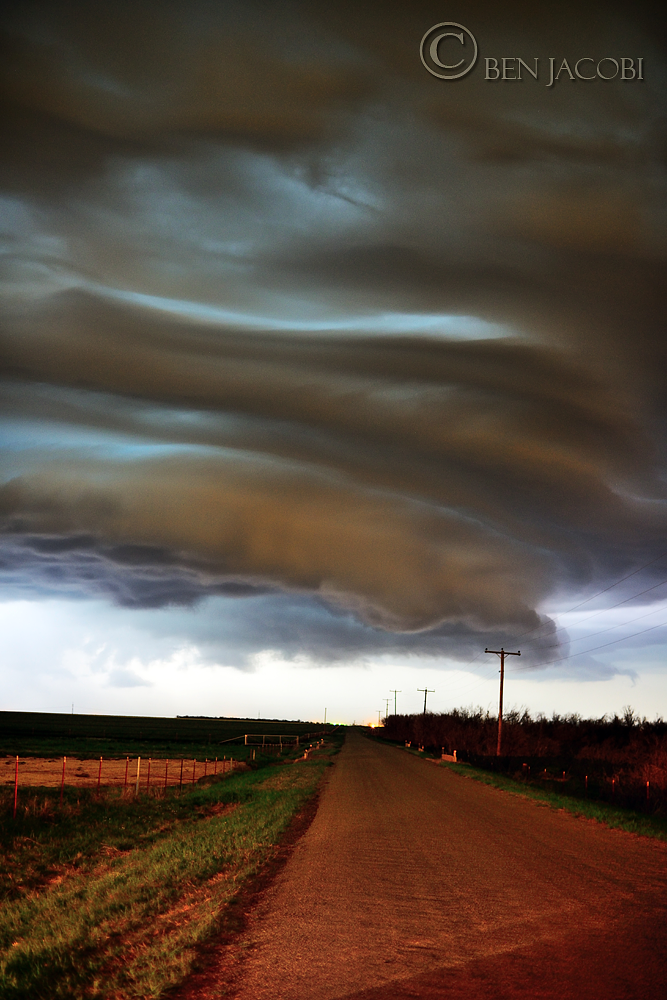 |
Just
long enough to get the shot I wanted and now it was time to head back
home. More than likely the storms were starting to congeal and we'd
have a good gust front on our hands.
|
The
storms follow me all the way to my apartment in Wichita Falls.
Driving back was difficult with all the rain and wind, but I made it
to my apartment just in time for the storm to hit Wichita Falls and
SAFB. In fact Burkburnett reported a 58mph wind gust and I believe we
had similar winds in Wichita Falls as well. Below is a link of a
video I made for the highlights of my March 2015. So March certainly
has been different than the previous years and I'm hopeful its an
indication on how the severe weather season will go. As I am typing
this I am also looking at the models for the possibility of severe
weather next week. This next storm system that comes through looks
more like a normal spring storm system, but only time will tell. So
far 2015 is shaping up to be a pretty good year.
Amazing shots, Ben. Even your grab shots at 60MPH are fabulous!
ReplyDelete